Erstwhile

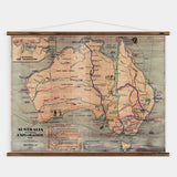
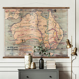
Australia Exporation Map

SKU: ERSTW-002a

$359 AUD
Size:

Available artwork sizes: 130x106cm & 112x92cm

This large-scale feature piece is a reproduction of the original 1938 wall map "Australia: Pictorial Exploration Map“, published by Chas. H. Scally & Co., Wollstonecraft, NSW. It is map no. 117 in the series and shows historic routes on land and sea, with the inset Crossing the Mountains (Blue Mountains). Reproduced with exquisite care and accuracy to preserve the beautiful aged look and wear-and-tear from years of use. The artwork has been printed on a fade-resistant, heavy-duty synthetic canvas, with its brilliant colours and accurate detail carefully restored. Hand-mounted with aged timber batons and 100% cotton rope. Each artwork comes rolled and ready to hang, individually wrapped in a protective cotton sock and sturdy cardboard box - perfect for shipping and storing. 

We will ship your order within 5 working days. Please allow 5-10 working days for your order to arrive depending on your location. Please let us know if you need your order delivered at a specific date and we will try our best to accommodate the request. However any delivery date or time specified by us is our best estimate only, and Erstwhile will not be liable for any loss or damage suffered by you through any unreasonable or unavoidable delay in delivery. Orders are subject to availability. You may be required to pay further shipping charges where a change in delivery date or delivery address is requested by you.

Please Note: Due to the current global shipping limitations, there is a temporary $45 shipping surcharge (charged by our freight partner) for any order of our extra large maps (over 1.2m wide). 

Please use a damp cloth to gently clean off dust if necessary. Do not use cleaning products of any kind.

You may also like

Recently viewed